| Clear
Creek Natural Bridge Day Hike Green River Lakes to |
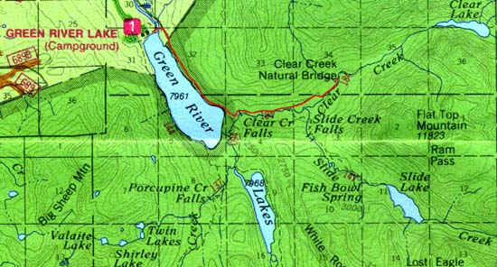
Trip Highlights: Green River Lakes, Square Top Mountain, Clear Creek Falls, Slide Creek Falls, Clear Creek Natural Bridge. Other: 1988 lightning fire burn, wildflowers, wild raspberries, beautiful scenery, wildlife. Trail Distance: 8.2 miles round trip, 2.5-4 hours depending on how much you stop and look around Trail Start/End: Green River Lakes Campground Difficulty: Moderately easy Traffic: Moderate to heavy, depending on season Elevation change: 8,050 feet climbing to 8,300 feet Cautions: See below Our opinion: Good family day hike. Bring your camera! |
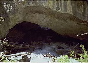
| Hike at a Glance: The Clear Creek Natural Bridge is easily accessible via the Clear Creek Trail from the Green River Lakes Campground. This natural bridge is formed by water undercutting and penetrating a resistant wall of limestone sedimentary rock in the Clear Creek Canyon. The upstream side of the opening is approximately 40 feet wide by 15 feet high. The downstream exit opening is much smaller, approximately 20 feet wide and 4 feet high. Natural bridges such as this are rare. This is a great day hike for the whole family. You'll see beautiful views of Green River Lakes and Square Top Mountain, waterfalls, mountain meadows and streams, wildlife, and views of scenic mountain country. If you're observant, you might find some wild raspberry bushes along the way with delicious berries. The trail is moderately easy with just a couple of climbs, but none too steep. |
 From
the trailhead at Green River Lakes Campground follow the Highline Trail
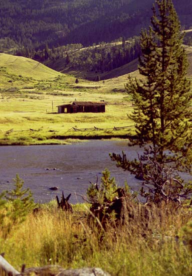
to the left. Just a short distance down the trail you'll come to the famous
Green River and through the trees you'll be able to see the Osborn cabins
homestead across the stream. Lots of folks stop right here and try their
hand at fishing this famous river. From
the trailhead at Green River Lakes Campground follow the Highline Trail
to the left. Just a short distance down the trail you'll come to the famous
Green River and through the trees you'll be able to see the Osborn cabins
homestead across the stream. Lots of folks stop right here and try their
hand at fishing this famous river.
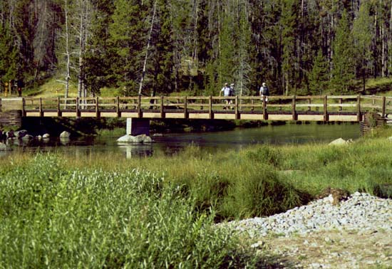
Continue down the trail and you'll soon cross a bridge over the outlet of the Green River. The trail forks just past the bridge. The left trail is part of the Continental Divide Trail system that takes you up to Gunsight Pass and a spectacular view of 5 mountain ranges: the Wind Rivers, Absaroka, Gros Ventre, Wyoming Range and the Tetons. That hike has long grade steep climbs and is for hearty hikers. We want to instead veer right and follow the Highline Trail along the northeastern side of lower Green River Lakes.
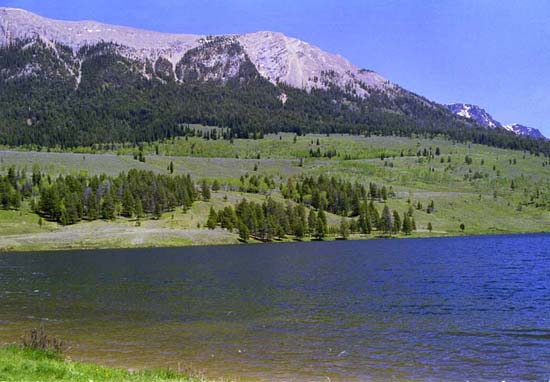
The mountains and valleys of the Wind River Mountains have been shaped by a series of glacial advances that took place over the past 200,000 years. The most recent Pinedale glacial advance was from 70,000 to 15,000 years ago. During these periods, snow and ice accumulated in the high mountain valleys eventually creating a moving wall of ice in the form of a glacier, which flowed downhill and carved spectacular U-shaped valleys and pushed debris and eroded rock in front of it like a bulldozer.
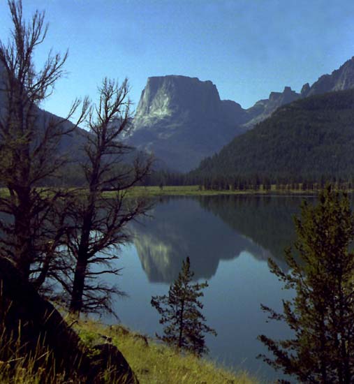
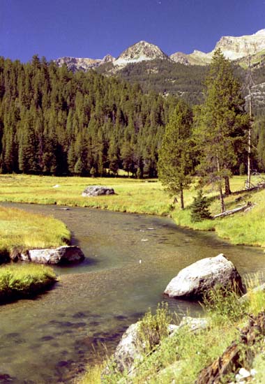
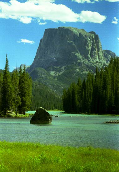
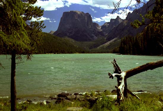
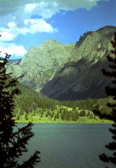
The larger glaciers, like the Green River Lakes and Fremont Canyon glaciers, carved their way to the base of the mountains and moved over the floor of the Green River Basin. When the ice from the glaciers finally melted back into the high canyons, they left natural moraine dams across the paths of the meltwater streams and moraine-dammed lakes which we see today. The high peaks of the Wind River Range above Green River Lakes are home to the Dinwoody Glaciers, the largest accumulation of active, alpine glaciers in the Continental United States. The view of Square Top Mountain along this portion of the trail is quite spectacular. Early in the morning the water in the lake can be very calm to give almost mirror-like reflections of Square Top in the lake.
|
| Follow the Highline Trail for 1.9 miles along lower Green River Lakes
to the junction signed for Clear Creek Canyon and take the left hand trail.
The trail to the right leads to the upper Green River Lake and around the
southwestern side of Lower Green River Lakes and accesses many popular
areas in the Bridger Wilderness.
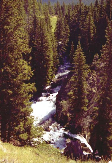
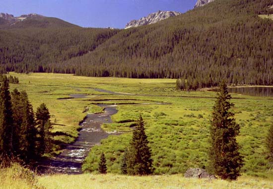
The Clear Creek Trail to the left begins with a moderate ascent through open slopes. It follows the rim of the canyon's and passes where Clear Creek plunges over a thundering waterfall. This is a spectacular view, but also a dangerous cliff edge, so children should be carefully watched here. The trail becomes nearly level beyond the falls and passes through a pleasant open pine forest. This later opens up with views of an expansive meadow through which Clear Creek meanders. If you're fortunate, you might see moose or deer in the meadow. 11,823-foot Flat Top Mountain can be seen here as well as a scenic view of other rugged crags. Stop for a rest, a picnic, or to fish the stream if you wish.
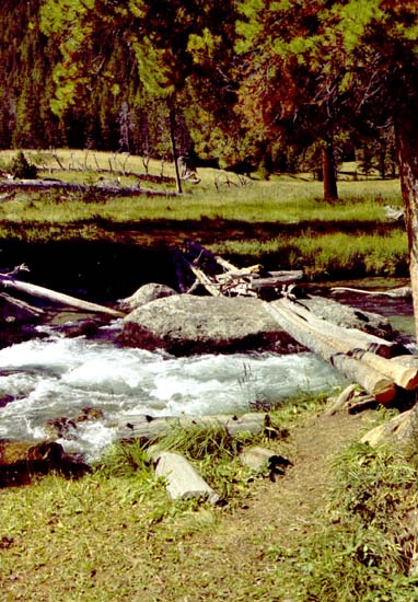
About a mile from the Highline Trail junction you'll come across the sign for the Slide Lake Trail which branches off to the right. This trail starts with a footbridge consisting of logs slashed together spanning Clear Creek. (This footbridge was repaired by Forest Service crews in the summer of 1999.)
The logs are perched high above the tumbling stream and meet on a boulder at mid-stream. A stock ford lies a few yards upstream of the footbridge. We stay on the main trail however and continue following the sign to the Natural Bridge. Our trail continues eastward and passes through an open lodgepole forest along the edge of the large meadow. Across the meadow you'll see Slide Creek Falls tumbling through the forest on the south wall of the canyon. There may be a couple of places along the trail here where you'll need to hop across springs or wet places, depending on the time of the year you're doing this hike, but for the most part this is a very easy walk.
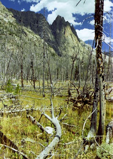
About a half mile from the Slide Creek junction, our trail cuts across the northwest edge of the meadow through an open grassy area filled with wildflowers. You can find blue harebells, cinquefoil, yarrow, subalpine daisy and a variety of other colorful flowers. Beyond here, the trail enters the charred burns of an old lightning burn from 1988. These old snags provide wildlife habitat for many wildlife species including a variety of woodpeckers and cavity-nesting birds. Grasses, wildflowers, and young lodgepole pine trees are reclaiming
the area. You'll soon come to a log crossing of a small tribuary stream and from here look ahead and you'll be able to see a prominent limestone wall that drops off the northwestern flanks of Flat Top Mountain and blocks the canyon upstream.
|
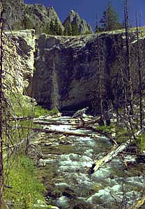
| The trail follows the streambank north and you may have to climb over
some downed trees and over logs if the Forest Service trail crews have
not yet been up to clear the trail. You will be able to see Clear Creek
flowing out of the downstream opening of the Clear Creek Natural Bridge
from along this portion of the trail. The exit opening is about 20 feet
wide by about 4 feet high. If you're observant, you might find some wild
raspberries growing along the trail along here too.
To see the upstream entrance to the cave, follow the trail around the limestone wall to the back side. At this point the cave opening is approximately 40 feet wide by 15 feet high.
Our tour ends here and turns around at this point to head back down the way we came to the Highline Trail. If you wish to continue on the Clear Creek Trail, you can hike for about another 1-1/2 miles to get to Clear Lake. The trail is not in very good condition, however, and is unmaintained. |
| Back at the Highline Trail junction veer left and cross the bridge
across Clear Creek.
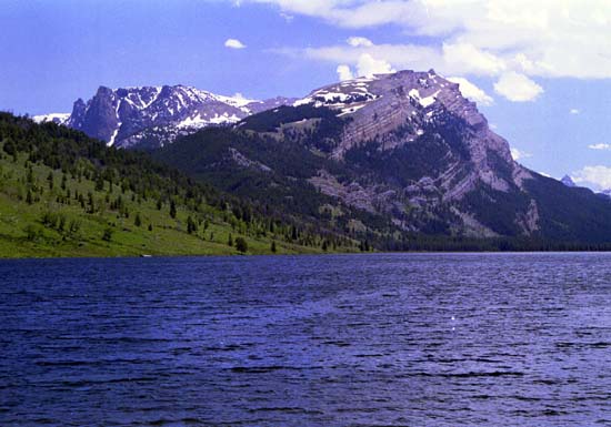
The trail then takes you to the open meadows between the upper and lower Green River Lakes. Take the time to hike over to the Upper Lake and notice the dramatic color difference between the two lakes. You'll see another spectacular view of Square Top Mountain and have opportunities again to fish, picnic, or explore the area between the two lakes. The wind can get fairly strong here as it comes down the canyon across the lake, which can be nice to keep the bugs off. There are several unimproved camping places throughout this area and it's a nice place to spend some more time wandering around and enjoying the views of Square Top Mountain.
The aqua color of the upper lake is due to the fine white silts that flow into the lake from the glaciers high in the mountains. These silts quickly drop off as the water flows into the lower lake creating the dramatic color difference between the two lakes. |
 The
trail along the southwestern side of the lower Green River Lake is very
different from the first part. This trail is through pine and fir forest
for the entire length back to the campground. You'll catch only occasional
glimpses of the lake and views of the far side along the way. The trail
crosses multiple small springs along this side that are no more than a
small hop across rocks. Mosquitos and horseflies are a bit more prevalent
along here, but on a very hot day, you'll welcome the shade and this is
a great way to get back to your starting point. The
trail along the southwestern side of the lower Green River Lake is very
different from the first part. This trail is through pine and fir forest
for the entire length back to the campground. You'll catch only occasional
glimpses of the lake and views of the far side along the way. The trail
crosses multiple small springs along this side that are no more than a
small hop across rocks. Mosquitos and horseflies are a bit more prevalent
along here, but on a very hot day, you'll welcome the shade and this is
a great way to get back to your starting point.
Once you get back to the campground and parking area you'll be able to see the Green River Lakes Lodge nestled in the trees next to the Green River Lakes Campground. This rock and log lodge was built in 1954 as part of the Gannet Peak Bar Ranch which operated for more than 30 years as a dude ranch. The GP-Bar Ranch and buildings were purchased by the government in 1966 to acquire the lakeshore and surrounding property to put into general public use. Today the lodge is closed and used only on an occasional basis.
The Green River Lakes Campground has 39 units and 3 group sites. No reservations are required, but there is a small fee to use the campground units. Trails from the campground area access the Bridger Wilderness area and many popular hiking destinations. The road to this campground typically opens mid to late June. (See our campground page for more details.) The Clear Creek Natural Bridge makes a great day hike or part of a longer stay in the scenic upper Green River Valley! |
| Directions: How to get there from Pinedale: From Pinedale this is an 52 mile trip to the Green River Lakes Campground. Take Hwy 191 west 6 miles to the Cora Junction and turn north on Hwy 352. The first miles of this road are paved highway and you'll go through rolling sagebrush hills that are open range to livestock and antelope with beautiful views of the Wind River mountain range on your right and the New Fork River in the valley. After miles, you'll cross the boundary onto National Forest land and the end of pavement. The dirt road has been widened and improved, but still expect to travel more slowly along this portion. Between here and the Green River Lakes campground you'll see many views of the Green River, a world-famous fishing stream. There are 2 historical markers along the way describing the tie hack history of the turn of the century along the river and the Gros Ventre Lodge. Your nose will tell you when you pass the sulphur springs, evidence that we are tied into the system of geothermal activity that links to Yellowstone National Park 100 miles to the north. Just past the bridge is Kendall Warm Springs, home of the 4" long Kendall Dace, found nowhere else in the world. These fish are cut off from the main Green River by a waterfalls at the confluence of this stream and the river. Green River Lakes Campground has overnight camping (39 units, no reservations, Campgrounds), restrooms, boat facilities, horse corrals and a wilderness trail entrance. |
|
E-mail: support@PinedaleOnline.com Area
Attractions | Outdoor Recreation |
Events Calendar | Newcomer's
Info | Businesses
Where am I? Pinedale Online! Front Page=>Virtual Tours=>Clear Creek Natural Bridge Take me to the Site Map. |